")
Flood warning siren in Venice (from Sounds Like Noise)
Visiting Venice this summer suggested some intellectual bridges between cities (see our previous series on the Urban Anthropocene), and our new theme (Perceiving the Anthropocene). How do cities help us perceive the Anthropocene—as it is inscribed on the cityscape, and as it is perceived by hordes of human and mechanical “sensors” distributed around the city? What urban environmental changes can we expect in this new epoch? Can Venice’s long engagement with high water provide ways of thinking about the Anthropocene epoch’s rising seas, shaping what kinds of responses might be possible?
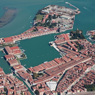
 In early June, I traveled to Venice to attend the second “Interdisciplinary Perspectives on Urban Infrastructure: History and the Social Sciences” conference organized by an interdisciplinary group of scholars from NYU’s Tandon School of Engineering, Dept. of Technology, Culture & Society; NYU Shanghai; the New School University Urban Studies; and the Università Ca’ Foscari, which generously hosted the conference in a well-appointed conference room whose grand balconies overlooked the Grand Canal. Coffee breaks afforded spectacular vistas and became occasions to reflect on Venice’s unique infrastructures.
 Venice is a striking study in urban infrastructure, especially in regard to mobility. The only two practical means of transport are walking and boating. Its lagoon ecosystem, shot through with human-made canals, makes boats the dominant form of motorized transport in the city. This system reflects the canal/street plans of medieval and early-modern construction, from an era when sail-boating was the dominant form of rapid, long-distance transport in the world, and Venice was a powerful, cosmopolitan port and seat of empire.
The conference theme this year was “the Fragile City,” an idea that I have often found useful to think with in my research on Paris infrastructure. Key topics over three days of lively discussion were: urban technologies, planning, services, environments, disasters, and resilience. Venice, a quintessential “fragile” city, is perhaps the perfect place to contemplate how cities, technologies, and environmental changes collide in unpredictable ways, creating risks that challenge urban resilience. Venice has been emblematic for prophets of urban decay and decline, a city expected to disappear, destined to drown one day in the Adriatic as another Atlantis (see, for example, these features at PBS and The Guardian).

These dire forecasts reflect Venice’s twin recurring environmental problems: (1) the city is often flooded by extreme high tides, rising seas, and coastal erosion; (2) the city is sinking thanks to land subsidence caused by pumping out groundwater for post-war industrial development. The environmental costs of Europe’s “economic miracle” were ignored too long–though more recent plans have sought to raise Venice back up by pumping in water underneath it; see here and here. These twin environmental risks have renewed Venice’s status as a poster-child for coastal defense in our own age of surging seas and storms. As a famous high-water city, Venice faced the problem of rising seas long before climate change was on the public agenda. But now that the whole globe is in the same sinking ship, Venice seems more familiar and relevant than ever as a fragile, but hopefully a resilient, place.
*

Our conference toured the command office of the MOSE mega-project (Modulo Sperimentale Elettromeccanico, or “Experimental Electromechanical Module”), a multi-billion-Euro suite of giant hinged hydro-pneumatic gates designed to keep the Adriatic sea out of the Venice lagoon in times of “high water” (Acqua Alta).
 The MOSE offices themselves also dealt with urban decay in another constructive way, as part of a project to renovate the long-disused campus of the Venice Arsenal and its historic architecture. When Venice was the seat of an empire, a state-of-the-art naval arsenal was necessary. But by the late twentieth century, the Arsenal sat disused and in disrepair. Thus, historical preservation and geo-engineering have run together in this sinking city, underscoring that Venice is dogged by recurrent questions of urban decay, repair, defense, and resilience.
 MOSE staff showed us this brief introductory video (there are others here, here, and here). A massive piece of environmental engineering, MOSE’s four gates can temporarily close the Venice lagoon’s three tidal inlets, holding back the sea…for a time. But for how long given rising sea levels? MOSE promises to protect Venice from up to 3 meters (almost 10 feet) of water. In a lively Q&A with MOSE staff, we conference-goers opened a searching discussion of just how much time the city can buy with 3 meters of protection, without reaching much consensus. No doubt many Venetians are searching for those elusive answers, too. What MOSE staff played down in their presentation to our group was the heated controversy around whether the multi-billion Euro project was a legitimate use of public works funds, and perhaps even a “failure.” Foreign observers and Venetians alike have their doubts.

Even visitors to Venice quickly perceive signs of high water in the streets. One visual example is plaster stucco eaten off of the facades of buildings by salt water, revealing the stones or bricks beneath. The facades of some shops and other buildings are marked with water lines dated for major floods, especially the extraordinary flood of 1966.
When the streets are dry, the city’s paved surface is defined by a tangle of narrow pedestrian-only streets opening onto pleasant squares or campos dotted with benches, trees, and fountains. This twisted street plan includes many places where one cannot cross a canal, and streets that turn a corner only to reach a dead end. Tourists are constantly getting lost, turning around, and pointing at maps or mobile phones under furrowed brows.
To this geo-informatic mess, now imagine adding high water. One night, as the conference attendees left our dinner restaurant to walk home, the tide was rather high and the canals had been topped-off by a brief rainstorm. Leaving late in the evening, we found several streets a centimeter deep in water and had to turn back. In addition to blocking pedestrian traffic in unpredictable ways, high water also disrupts boat traffic, by raising boats up too close to bridges, potentially trapping them in a section of canal/s. While we who left the restaurant on foot took a circuitous route to get home, another colleague’s boat ride was delayed for over an hour until water levels dropped enough to make canals safely navigable again. Though Venetians may know the city’s low points by memory and avoid possible bottlenecks on high-water days, the city’s thousands of tourists and conference-goers cannot. Venice’s lattice of canals and streets changes under high water; its unique mobility infrastructure presents unique vulnerabilities.
Paul Edwards has shown that the Anthropocene has its own “knowledge infrastructures,” large sociotechnical systems that collect weather and climate data, using human or technological sensors, allowing us to record, map, study, and better understand global ecological change, as well as software models to make forecasts. High water “sensing” is a refrain in recent flood control efforts, with electronically and sonically distributed signals, flood warning systems, and “smart levees.” MOSE is shot through with information infrastructures that monitor the Adriatic and control the gate machinery accordingly. MOSE not only helps Italians hold back the swelling sea, it helps them perceive or detect when the sea is rising. Accordingly, the MOSE gates are only triggered to raise when tides reach 110 centimeters, although the lowest parts of Venice start flooding at 80 centimeters.
MOSE is only one in a group of systems that allow Venetians to perceive rising water in their environment and responding accordingly. High water is forecast as a regular part of weather news, and there is a warning system of sirens whose different “songs” indicate various levels of water. After living in Venice for a while, one could become quite seasoned in listening for high water.

Seeing the traces of high water having washed plaster from facades, hearing the high water warning sirens, sensing the rising Adriatic through MOSE equipment—these are not only ways that Venice builds resilience in a world of floods, storms, and rising seas. They are also ways that Venetians perceive the Anthropocene, by using their senses locally to detect traces, signs, or indexes of human-made environmental change. In so doing, Venetians are constructing knowledge about the Anthropocene. If Venice is a feast for its visitors’ senses, the city offers other perceptual cues for more seasoned locals. High water is perceived in the squeak of rubber boots, splashing footsteps, or the silence of boat engines. Time will tell whether the MOSE ends in hybris, folly, or failure rather than in success. But in the meantime, Venice offers imaginative ways to perceive the coming anthropogenic high-water future of coastal cities around the world.

Pingback: Sensing High Water in Venice — Inhabiting the Anthropocene | msamba
Three-quarters of Venice is currently flooded, with reports of water up to 156cm deep! https://www.theguardian.com/world/2018/oct/29/venice-experiences-worst-flooding-since-2008?CMP=share_btn_fb&fbclid=IwAR2HzKx5z3L2JCCFCtdOD4Q9eBDyx24xTj3bNI_G6IgWCbq_TO0TnaNlv8E
More coverage here: https://www.nytimes.com/2018/10/30/world/europe/venice-floods-italy.html?action=click&module=News&pgtype=Homepage&fbclid=IwAR0NkvbYg5l5olLNVU4433stLM3LzVVulGd7vzm3sTeoGo7S9zJ3eozYlvk
And sadly, yet again–the worst in 50 years. (For the New York Times coverage, click here: https://nyti.ms/2QhgbdV) Blog contributor Robert Bailey and I took a study abroad group to Venice this past July; the descriptions in the story hit very close to home. The loss of pillars of our heritage makes the cultural meaning of climate change more explicit–and more painful.